Florida is a favorite destination among vacationers, especially during the summer months. It’s home to the Walt Disney World Resort, Universal Studios Orlando Resort, SeaWorld Orlando, Busch Gardens, and other theme parks. The beautiful blue waters of the Atlantic Ocean greet visitors to the Space Coast, Cocoa Beach, and other sandy spots on the eastern coast of Florida, and the warm temperatures all around the state beckon residents and visitors alike to step outside and drench themselves in the summer sun.

But for all the thrilling attractions, sandy beaches, and copious dining venues around the state, danger lurks in the Sunshine State–a danger that has been costing native Floridians and vacationers their lives, and Disney World Guests, as well as guests of other destinations in Florida need to be on alert.
Record Heat Grips the United States
According to the National Oceanic and Atmospheric Association (NOAA), temperatures across the United States were higher than usual in the month of June. From the Pacific Northwest to the Northern Plains, and in the Southern Plains as well as the Florida Peninsula, temperatures soared above average. The state of North Dakota recorded its third-warmest June ever, and both Louisiana and Minnesota experienced temperatures that landed June 2023 among the top ten warmest Junes in recorded history.
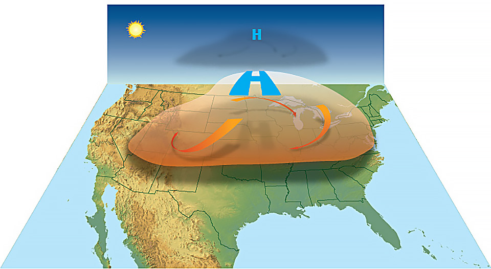
The country isn’t only experiencing a heat wave, but a series of heat waves, as well as a new-fangled thing called a heat dome, which isn’t nearly as interesting or impressive as its name sounds, though it does pack a punch. A heat dome is a weather phenomenon that occurs “when the atmosphere traps hot ocean air like a lid or cap,” according to the National Oceanic & Atmospheric Administration (NOAA). As part of this phenomenon, “high-pressure circulation in the atmosphere acts like a dome or cap, trapping heat at the surface and favoring the formation of a heat wave.”
In early June, a massive heat wave led to life-threatening conditions in Puerto Rico: heat index values maxed out at 125 degrees, and on June 6, 2023, the city of San Juan broke its all-time daily temperature record. The northeastern United States, as well as the mid-Atlantic and Great Lakes regions, experienced record-high temperatures brought on by another heat wave. New high-temperature records were set in Michigan, New York, and Vermont, and in the southern Plains, including the state of Texas, temperatures soared above 100 degrees. The city of Rio Grande Village, Texas, set a new record for the state–119 degrees Fahrenheit, and that doesn’t account for the astronomical heat index values.
Temperatures were above average from the Pacific Northwest to the northern Plains, as well as in the southern Plains and the Florida Peninsula in June. North Dakota saw its third-warmest June on record, while Louisiana and Minnesota each had a top-10 warmest June on record.
Warnings From Government Agencies Abound
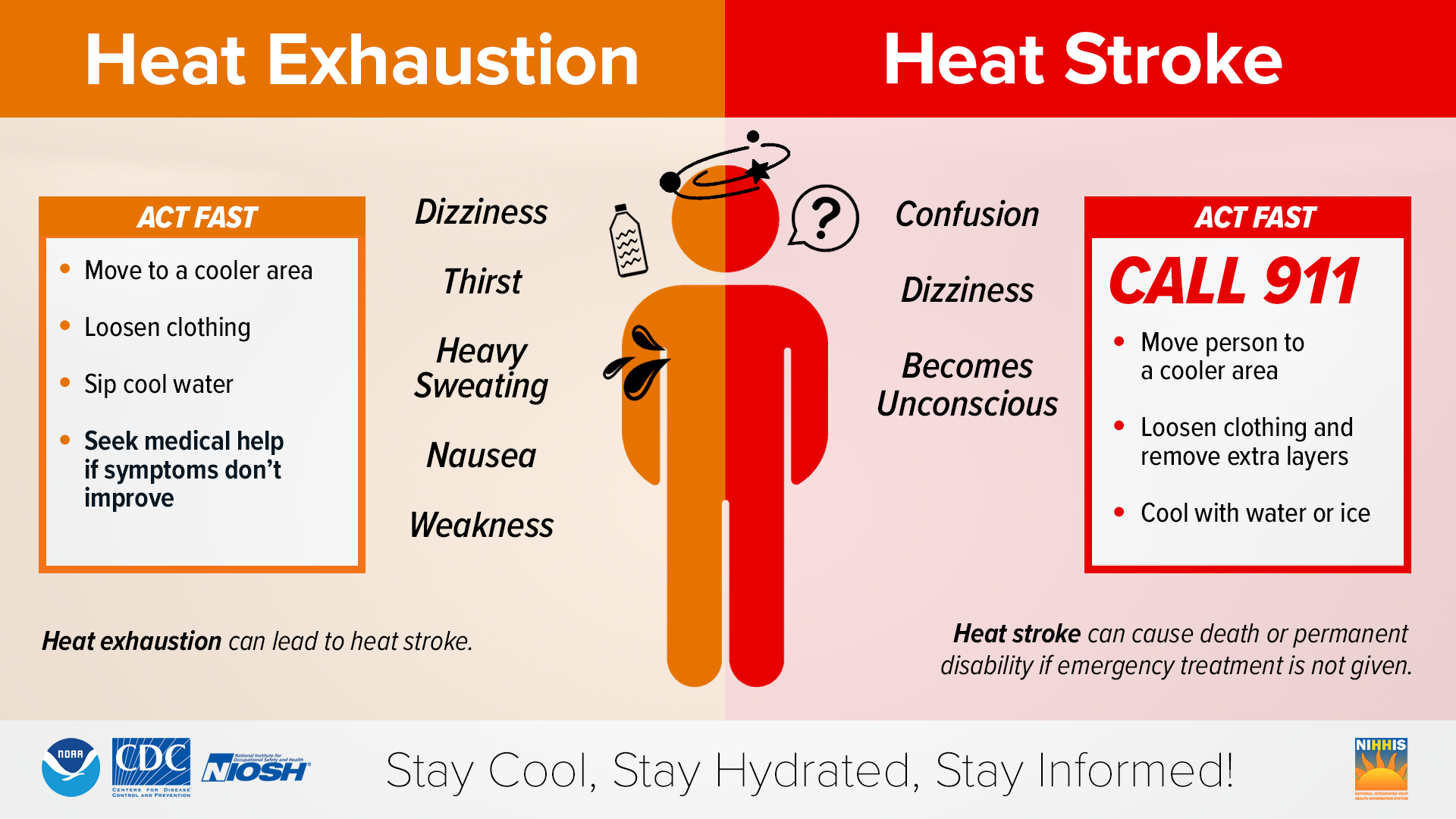
High temperatures, high humidity, and the threat of heat-related illness and stroke spurred Florida’s Emergency Management Department to issue a serious warning to residents and visitors in the Sunshine State in late June, advising them of the high temperatures and the need to stay hydrated to avoid the threat of heat-related illnesses like heat exhaustion and a more serious condition: heat stroke.
https://twitter.com/FLSERT/status/1673703219896152066
On Wednesday morning, the National Weather Service issued warnings and advisories for the next seven calendar days in the state of Florida related to the excessive, sometimes unbearable heat. The advisory notes high temperatures and high humidity levels and explains that such a combination will yield extremely high heat index values–as much as 107 to 110 degrees Fahrenheit.
EXCESSIVE HEAT IMPACT: A Heat Advisory is in effect until 6 p.m. for Okeechobee, St. Lucie, and Martin counties. In these locations, the combination of high temperatures in the mid-90s and high humidity will result in peak heat index values of 105 to 110. Farther north, highs in the low to mid-90s and high humidity will produce heat index values of 102 to 107 this afternoon. If you will be engaged in any outdoor activities, drink plenty of water, take frequent breaks indoors or in the shade, and protect yourself from the sun by wearing sunscreen and a hat.

The National Weather Service has issued additional warnings and advisories effective Thursday, July 13, through Tuesday, July 18, that include the threat of continued above-normal temperatures and high humidity, making for an extremely high heat index, or “real-feel” temperature, some days, especially later in the week. Daily heat index temperature values may reach extremes of 110 degrees. The threat of lightning storms exists throughout the next seven days, and strong storms in the area may produce powerful wind gusts, lightning strikes, and very heavy rain.
Scattered daytime and evening lightning storms will continue through the remainder of the week and into the weekend. The strongest of storms will produce gusty winds, frequent lightning strikes, and heavy rainfall. Localized instances of flooding are possible. Afternoon temperatures will remain above normal, with humidity remaining high. Peak heat index values will reach 102 to 110 into the weekend, especially late in the week, as high pressure continues to build across the Florida Peninsula. Remember to protect yourself from the heat and sun.
A study conducted by Dr. Ziwen Yu at the University of Florida found that between 2010 and 2020, 215 heat-related deaths occurred in the Sunshine State. Each year, the number of deaths ranged from 10 to 28, and average temperatures during the hottest months of those years (May through October) aligned with the fatality trends. Between 2010 and 2020, the majority of heat-related fatalities occurred in the month of June (53 deaths), followed by July (43) and August (42).
Take care out there, and be sure to drink lots of water and take rest breaks. Don’t become a statistic during your visit to Disney World.